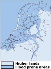
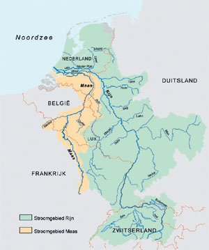
Holland as a flood-prone area The Netherlands is situated in a low-lying delta where the rivers Rhine,
Meuse, Scheldt and Ems debouch into the North Sea. It is a very flood
prone country: about 60% of the country is situated below sea-level, 9
million people live here and about 65% of the Gross Domestic Product is
earned here.
Because of this, Dutch flood protection policy concentrates on
prevention against floods, i.e. minimizing the probability of flooding.
However, absolute protection is impossible, there will always remain a small
chance that strong and impressive protection works fail. The flooding of
New Orleans (September 2005) has illustrated the damage and disruption
that may occur when large metropolitan areas are flooded. Therefore, in
addition to flood prevention, it is crucial to be prepared for flooding as
well.
This policy is needed to minimize damage, casualties and disruption
when the rare disaster becomes reality. In this respect flood risk maps play
a vital role for spatial planners, citizens, companies, network- managers and administrative authorities
(Quotations from the website safety.org, Dutch Ministry of Transport, Public Works and Watermanagement, Climate changes. Dutch watermanagement. Netherlands
Waterpartnership publication August 2007 , Climate adaptation in the Netherlands,Wageningen University publication May 2006, CT 4061 Noordwaard, Delft University of Technology publication October 2004)
Room for the river
In 2006 the Dutch Government drew up the Spatial Planning Key Decision "Room for the River"
This decision was made to find a way for rivers to cope with greater volumes of water in a safe manner
The extreme high water levels of 1993 and 1995 when 250,000 people had to be evacuated from Hollands main river basin , gave rise to this decision.
In 2015 the Dutch branches of the Rhine river will safely cope with an outlet capacity of 16,000 cubic metres of water per second
High river discharges can be expected as a result of climate changes.
If a flood would occur the economic and emotional damage in the densely populated low countries would be huge.
The Rhine High Water Action Plan of the countries in the discharge area aims at reducing the high water levels an average of 70 cm by 2020
The traditional solution of raising and strengthening the dykes is not suitable anymore to cope with the growing water discharge of the main rivers
Better flood protection contains measures like deepening the forelands of the rivers, enlarging of summerbeds ,displacing dykes further inland, lowering of groynes in the rivers, and the so called de-polderisation , (turning well protected dyke rings into flow areas). Spatial planning Key Decision, ROOM for the river (pdf 1.3MB)
The Holland Floodproof touring programme of HollandTheRideWay consists of
two tours in two different parts of the country, namely the Water castles and Watermanagement tour in the Main River region in the central part of Holland and the Inflatable Dam tour in the north-eastern part of the country.
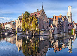
THE WATER CASTLES AND WATERMANAGEMENT TOUR
This full day tour will show you the imposing river landscape of the tributaries of the Rhine and Maas rivers, a medieval castle, flood proof buildings like floating houses, a
historical steam pumping station, a landart project as a means of nature development ,a flood protection project which turns fertile agricultural land into a unique overflow area and an Unesco World Heritage Monument drainage system consisting of 19 traditional windmills A visit to a fort of the so called Holland Waterline Defence system can be part of this tour.
This tour can be taken in separate parts or also as one unit.
During this tour we will explain the Dutch policy regarding the large rivers :Room for the River, while there is time for relaxation and enjoyment of the beautiful Dutch river landscape with its swinging dikes, cutoff river bends, flood plains, swamps, ferries, bridges, brick factories, wind mills, water pump stations, historical city centers and not to forget the navigation traffic.
This tour is also interesting for children; certainly the eastern part in which there is action and the individual parts of the one of the most beautiful castles of the Netherlands, strategically located at the confluence of two large Dutch rivers.
From this Medieval location we drive either toward the West or East into the Dutch river landscape.
A. Crescent Moon Tour (going West)
Passing through a picturesque town on the river and a fort of the Dutch Waterline Defense System, we drive West to the former tides area, a National Park, which became, due to the construction of the Delta dikes in the sea arms of South West Holland after the storm surge disaster of 1953, an area of strongly reduced tides and correspondingly lower nature values.
The area came into existence after a large flooding disaster in 1421, by silting from the large rivers, building dikes and drinking water extraction by man.
These are mostly wetlands with a vast network of narrow and wide creeks, reed lands and marshes. By Government policy Room for the River, parts of the agricultural area will be changed into a lowland stream drainage basin, which will allow a quicker drainage for river water at times of high water levels in the rivers. Here we will visit a land art project in which the ideas of the project Room for the River are coupled with the redesigning of the landscape with improved nature values.
Time allowing there are possibilities to make a boat trip in the creeks, a walk in the beds of willows and polder woods of the National Park. By ferry over the river, we reach a 18th and 19th century windmill complex, which is a Unesco World Heritage Monument. We conclude the tour in a historical town with a visit to a water tower complex and enjoy a delicious meal in the renovated company buildings.
B. Floating Houses Tour (going East)
From the strategically positioned castle, we drive on the southern bank of an important navigation river. We visit an old fortified town which with its ring of walls and canals played an important part in the defense of Holland between 1580 and 1620.We pass by a water castle and visit a pewter caster who will show us his traditional trade. We then arrive at the floating houses, where you can see how the reducing of residence need is connected with the high water solutions.
Not far from here you can see in the pumping station, how the region of the rivers
was kept dry at the time of steam engines.
We drive then by means of a ferry over the river and by following roads on the dikes of an impressive river to a picturesque stronghold town, which is linked to the House of Orange, the Royal Dutch Family. You may walk on the defense walls and view the town that was constructed according to city plans.
After a possible dinner in the historical surroundings of this town we return to the starting point of your journey.
If time allows, we could stop on the way back at a fortress of the so called Holland Waterline Defense System.
C. The Inflatable Dam Tour
This full day tour combines a visit to a historical town which uses its medieval townwall as a flood protection device
Video Urban flood control :
A mobile waterdefence system in an historical Dutch town
Copyright Waterschap (Waterboard) Groot Salland
with a visit to a highly sophisticated Storm Surge. Barrier , the Inflatable dam , Visits to a 19 th century steam pumping station, a traditional Dutch canal village , called the Venice of the North, typical Dutch peat lands and a former island in a land reclamation are also part
of the touring programme of the Inflatable Dam tour.
During this tour, (which preferably starts in Amsterdam, so that the land reclamation project of the Zuiderzee Works can be explored) we drive in the area of the Netherlands where a branch of the Rhine ends in the IJsselmeer (formerly the Zuiderzee) and where part of the land reclamation of this project took place.
Higher water levels in the river due to the increased greenhouse effect , in combination with the impoundment of this river water with the North West wind,
increase the danger of flooding in this area, thence the construction of an Inflatable Dam. During this tour attention will be paid to pros and cons of the traditional dike reinforcements and the high tech solution of the Inflatable Dam.
We will also come across the contrasts between the tight and orderly organized new land of the IJsselmeerpolder (about 4 meters below sea level) and the adjacent old land, a peat landscape. In this peat landscape with traces of the former peat mining there are interesting touristic places to be visited, like a canal village and a formerly thriving trade center of the Dutch Golden Age (17th Century) with historical buildings, a beautiful harbour basin and an international renowned restaurant. If time allows, one could visit the largest steam mill in the world, also known as the Steam Cathedral. The return part to Amsterdam could run over the 32 km long Enclosure Dam, completed in 1932, as a closure of the former Zuiderzee, a salt water inlet of the North Sea.
Transfer/tour Amsterdam-Bruges/Brussels/Antwerp/Ghent via Dutch Delta Works
Example of a two day tour through the Low Countries (The Netherlands and Belgium) via the Delta works area in the provinces of Zuid Holland and Zeeland (Netherlands ) A transfer in one day from Amsterdam to Bruges via the famous Dutch Delta works will also be possible.
Duration , route , attractions and end destination of the tour can be adapted to your wishes
Flowers, Cheese farm ,Windmills, Delft Blue porcelain, Waterworks (storm surge barriers, dams , dykes of the Delta works ), Historical Towns and so on.
Travelling by minibus or by car , this journey can start in Amsterdam or any town of your choice.in the western part of The Netherlands You will see some typical attractions of the Low Countries.
This tour is the ideal way to get you to your next destination of your travel plans in Europe, while sightseeing along the way through the Netherlands and Belgium.
First Day
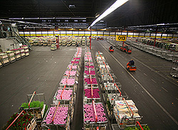
Early in de morning we start our tour in Amsterdam to visit the famous flower auction in Aalsmeer, just south of Amsterdam. It is the largest flower auction house in the entire world, in surface and total sales per day. The auction building has a surface of almost one million square meters (9 million sq ft!). 34.5 million flowers and plants change hands daily, on a yearly basis 12.5 billion !
Auctions clocks (38 in total) are used to sell the flowers and plants in a fascinating process and in fractions of seconds, large and small batches are sold. This auction system in Aalsmeer also sets the world wide pricing of flowers and plants.
We continue our tour along scenic rural roads to visit a cheese farm in the center of the green belt of Holland (the Green Heart). The farmer and his wife will welcome you with coffee while explaining the development of agriculture in this particular area. They will show you small scale Dutch cheese making, hands-on and of course you may taste the different styles and if you like purchase some.
Alblasserwaard
Driving over dikes, using a ferry to cross a river, we reach a Unesco World Heritage Monument. It is a series of 19 windmills, formerly used to keep the Alblasserwaard polder area dry. Here you can see from close up the working mill and make pictures of the photogenic Dutch landscape.
Delft
Delft, the city of the Delft Blue Pottery, is our next destination<. Famous historical figures like the painter Johannes Vermeer and the scholar in law Grotius lived here. The University of Technology here, with its Faculty of Engineering produced some internationally well known Dutch architects.
We will see the production process of the Delft Blue Pottery and visit the tomb of William of Orange, who was the founder of the State of the Netherlands. He was buried in the New Church downtown Delft.
Nieuwe Waterweg (New Waterway)
Then we are moving in the direction of the storm surge defense system in the Nieuwe Waterweg, (New Waterway), a typical masterpiece of Dutch Hydraulic Engineering. One may view this from a high positioned lookout, or see it at the exposition. As you wish, we can have lunch here with a view on the impressive steel construction of this water defense system, or enjoy lunch in the historic atmosphere of the city of Delft. It is also possible to go on a guided tour by an expert of the barrier.
The world port of Rotterdam
Continuing our way to a historical small town in South Holland, we cross the New Waterway by ferry. This water way gives access to the world port of Rotterdam.
In this town, were we can have a short stop, lived at one time the only Pope that the Netherlands produced. (Pope Adrianus VI, 1522-1523). The house, in which he lived, still exists.
Deltawerken
Diving over impressive dams of the Deltawerken, we entry the province (state) of Zeeland. This part of the Netherlands experienced a severe flooding in 1953, which caused 1850 lives.
Second Day
The Second Day of the tour you can clearly see at the Delta Expo, how the Dutch responded to the disastrous flood of 1953 by constructing the Deltawerken (Delta works). This masterpiece of Dutch hydraulic engineering, the storm surge barrier of the Oosterschelde estuary can be seen from very close by.In the so called Delta Experience you can get an impression of the strength of the severe European windstorm over the North Sea that occurred on the night of Saturday, 31 January 1953 and morning of Sunday, 1 February 1953. The floods struck the Netherlands, Belgium, England and Scotland.
Bruges /Brugge
Through a long, 6 kilometer tunnel under the Westerschelde estuary, which is the access to the port of Antwerp, we are on our way to Bruges in Flanders. The center of Bruges dates back to the Middle Ages and is put on the Unesco World heritage list.The painter Jan van Eyck , representant of the Flemish Primitives , lived in Bruges In the Groeninge museum his famous painting Virgin and Child with Canon van der Paele (14341436) can be admired Bruges was once the most important port of Western Europe and although it looks like an open air museum of architecture of the Middle Ages, it is very lively due to the 20,000 people that live in the old part of the city. While enjoying a beverage on a terrace at the market square the Grote Markt, you will admire the historical buildings surrounding you like the Belfort This leisurely watching is a wonderful experience. We also have enough time for shopping in town. A visit to one of the many chocolatiers with the many kinds of truffles, is highly recommended. . And a visit to Bruges isn't complete without a boat trip on its canals.
In the morning of the next (third day), our tour through the Low Lands, can be concluded with a trip from Bruges to Train Stations of Brussels South or Central (with connections to London and Paris), or another destination in Brussels or Belgium.
After visiting Bruges and/or Brussels ,Antwerp and Ghent is would also be possible to return to Amsterdam by a transfer by HolllandTheRideWay.
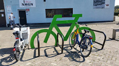
The average Dutch person now cycles about 1000 km annually. More than a quarter of the workers cycles to work.
The high frequency of bicycle travel in The Netherlands is enabled by flat land, short distances in a small country and excellent cycling infrastructure such as cycle paths, cycle tracks, cycle routes, protected intersections and bicycle parking.
Jewish cemeteries and synagogues in the northern Netherlands and adjacent Germany
The
smallest synagogue in the Netherlands The northern part of the country , a region with a rich
Jewish tradition, has the smallest synagogue. In the immediate vicinity,
hidden in the greenery there is a beautiful intimate Jewish cemetery.
Traces of German Jewish culture Also across the border, in Germany, you will actually
find traces of a rich Jewish culture. A trip to this place can very
well be combined with a visit to the city of Groningen or the nature
reserve of the Dollard, part of the tidal area of the Wadden region
and well- known for its bird-life. The province of Groningen is
also well known for its beautiful medieval churches and famous historical
organs.
Camp Westerbork In this camp, departure place for the train to Auschwitz,
Anne Frank was detained before her transport to the death final
camp.
A
completely different kind of tour is a visit to the harbour -, dock-
and industrial area of Europoort, west of Rotterdam.
Gateway to Europe Via water, road and railtransport Europoort has access
to a large hinterland in Europe. HollandTheRideWay shows you the
harbour-, dock- and industrial area of the world’s largest
port, Rotterdam, which provides about 300,000 people directly or
indirectly with employment and is good for about 11 % of the G.N.P
(Gross National Product)
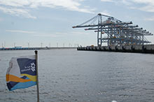
Land reclaimed for industries Oil refineries, chemical factories, container transshipment,
transshipment of ore, fruitdock, distriparks, centre for fire prevention,
sludgedeposit
The Slufter for polluted dredgings, and many more other activities
are concentrated in an area of partly reclaimed land, Maasvlakte 1.
Maasvlakte 2 is the latest western expansion of the Rotterdam port area in the North Sea. A total surface area of 2,000 hectares will be created by spraying on sand off the coast. This sand will mainly come from sand extraction sites in the North Sea. The total investment involved in the construction of Maasvlakte 2 is EUR 2.9 billion (2007 price level). For this amount, the Port of Rotterdam Authority is constructing the following elements at its own expense and risk: A new piece of land,seawall and basic infrastructure, such as quays, rail track and roads.
Early care of the elderly A court of almshouses is a complex of houses grouped round
an inner court, and inhabited by elderly people, mostly women, and
managed by a charitable institution. The foundation of a court of
almshouses can be seen as one of the earliest forms of care of old
people. As women were supposed to be more capable of running their
own households, there were no almshouses for men. That’s why
there was the Old men’s home.
Guided tour of 10 almshouses Haarlem is an outstanding example of an almshouses town.
HollandTheRideWay will show you 10 almhouses during which tour you
can also become acquainted with the historical city centre of Haarlem
and, on the way, have a look at one of the finest railwaystations
in the Netherlands, dating from the earliest day of the Dutch Railways
. In the 17th century Haarlem still boasted over 40 almshouses.
Of these there are now still 19 left.
This tour will not be possible after 17.00 pm and on Saturdays and Sundays.
Almshouse of 1395 It’s true that Leiden has more almshouses, but in
Haarlem there is a greater diversity of almshouses. Holland’s
oldest court of almshouses dates from as early as 1395. Most of
the still existing courts of almshouses were established after the
Reformation (1678)
Cheese press The cheesemuseum in North Holland shows you the specific
Dutch tradition of cheese-making and amongst other things a beautiful
collection of cheese presses.
Bird’s eye view of tulips In the environment of this provincial town bulb-growing
has expanded enormously in the past years. While cycling or walking
on the higher lying path in the dunes you can see on one side the
blue of the sea and on the other side the red and yellow of the
bulbfields.
Flemish beguinages, early
feminist enclaves in Belgium.
Since
1998 thirteen Flemish beguinages have been on the UNESCO World Heritage
List. A number of these have been included in the HollandTheRideWay
programme.
Beguinages have their origins in the Low Countries in the Middel
Ages. Part of the male population went on crusades to Jerusalem,
never to return. The surplus of women sougt support and comfort
with each other in the beguinage.
In all there are 29 beguinages in Europe, 25 of which can be found
in Belgium. There is not a single European country that boasts so
many relics from that time. Most of them can be found near chapel
or church.
A beguinage tour can easily be combined with a visit to the historic
cities of Ghent and Bruges.
La Route Van Gogh : back
to the roots of a world-famous painter
On
29 July 1890 the world-famous painter Vincent van Gogh died. On
30 March 1853 he was born in Zundert.
This cycling tour takes you to his place of birth in Noord Brabant
-a province of the Netherlands- where his father was a minister
of the still existing Dutch Reformed Church.
It also takes you to the places that young Vincent dressed like
a poor man visited on his rambles through the countryside of Noord
Brabant. An exposition about Vincent van Gogh's youth will give
you a further insight into the life of the painter as a young man.Cycling
through the narrow streets of Zundert, you will taste the 19-th
century atmosphere this village still exudes. The recently opened Vincent van Gogh House in Zundert has a presentation about the painter’s life, interactive education , a documentation room and permanent and temporary expositions .Tourist information and a pleasant bar with garden terrace are available for visitors
The trip is not complete until you have also visited the Noord
Brabant country estates where Van Gogh spent some time. In Nuenen,
where Van Gogh lived from 1883 to 1885 he completed his first famous
masterpiece The Potato Eaters. He made 196 paintings and 286 drawings
and aquarelles in his Nuenen period.
In this Noord Brabant village you can also visit some of the watermills
painted by Van Gogh and the Van Gogh Documentation Centre devoted
to Van Gogh's time in Nuenen.
Expert excursions
If you wish to go into the deep end and if
you have a more than an average interest in the world of art history
and
architecture,
then you may book expert excursions in those fields, provided by
drs Kees Kaldenbach. As an art historian he has appeared on BBC
and for Japanse TV teams. Each trip is carefully made to measure.
These are just a few options:
a) The Rembrandt house,
or the Rijksmuseum Amsterdam for an in-depth tour.
b) The Rembrandt walk in Amsterdam
c) The Vermeer walk in Delft
d) A visit to the Royal Collection Mauritshuis in The Hague,
with excellen paintings by Vermeer and Rembrandt.
e) Walks in Leiden, Gouda, Rotterdam, Haarlem,
Alkmaar etc.
f) Prior to these walks you may enjoy a Private
lecture.
g) Van Gogh tour: Amsterdam, Otterlo, Brabant.
A bike can help you escape from the city bustle of Amsterdam and discover the beautiful green scenery surrounding our capital.
On your bike you can get acquainted with the Dutch fenlands which
are so characteristic of the Dutch polder landscape. Relaxed and
at your leisure you will take in the beauty of an unfolding panorama
of windmills, drawbridges, meandering rivers and streams, low-lying
polders, peateries, lakes, nature reserves, old farmhouses and
beautiful villages. We can stop at the places Rembrandt used to
paint in.
All the information on the history of the landscape
can be provided by your guide, geographer Hans Noltes.

 Holland as a flood-prone area
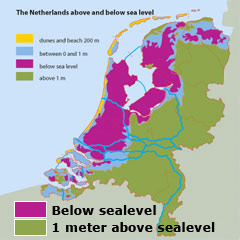
 If a flood would occur the economic and emotional damage in the densely populated low countries would be huge.
The Rhine High Water Action Plan of the countries in the discharge area aims at reducing the high water levels an average of 70 cm by 2020
If a flood would occur the economic and emotional damage in the densely populated low countries would be huge.
The Rhine High Water Action Plan of the countries in the discharge area aims at reducing the high water levels an average of 70 cm by 2020
 This tour can be taken in separate parts or also as one unit.
During this tour we will explain the Dutch policy regarding the large rivers :Room for the River, while there is time for relaxation and enjoyment of the beautiful Dutch river landscape with its swinging dikes, cutoff river bends, flood plains, swamps, ferries, bridges, brick factories, wind mills, water pump stations, historical city centers and not to forget the navigation traffic.
This tour is also interesting for children; certainly the eastern part in which there is action and the individual parts of the one of the most beautiful castles of the Netherlands, strategically located at the confluence of two large Dutch rivers.
From this Medieval location we drive either toward the West or East into the Dutch river landscape.
This tour can be taken in separate parts or also as one unit.
During this tour we will explain the Dutch policy regarding the large rivers :Room for the River, while there is time for relaxation and enjoyment of the beautiful Dutch river landscape with its swinging dikes, cutoff river bends, flood plains, swamps, ferries, bridges, brick factories, wind mills, water pump stations, historical city centers and not to forget the navigation traffic.
This tour is also interesting for children; certainly the eastern part in which there is action and the individual parts of the one of the most beautiful castles of the Netherlands, strategically located at the confluence of two large Dutch rivers.
From this Medieval location we drive either toward the West or East into the Dutch river landscape.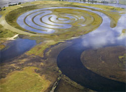


 The
smallest synagogue in the Netherlands
The
smallest synagogue in the Netherlands A
completely different kind of tour is a visit to the harbour -, dock-
and industrial area of Europoort, west of Rotterdam.
A
completely different kind of tour is a visit to the harbour -, dock-
and industrial area of Europoort, west of Rotterdam.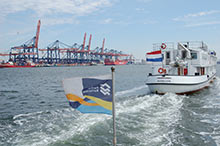
 Since
1998 thirteen Flemish beguinages have been on the UNESCO World Heritage
List. A number of these have been included in the HollandTheRideWay
programme.
Since
1998 thirteen Flemish beguinages have been on the UNESCO World Heritage
List. A number of these have been included in the HollandTheRideWay
programme.  On
29 July 1890 the world-famous painter Vincent van Gogh died. On
30 March 1853 he was born in Zundert.
On
29 July 1890 the world-famous painter Vincent van Gogh died. On
30 March 1853 he was born in Zundert. 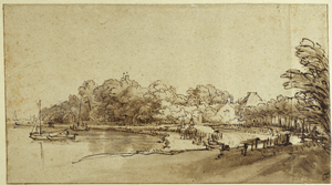 (Image title: Bend in the Amstel near Kostverloren House
by Rembrandt Hermansz Van Rijn (1601 - 1669)
(Image title: Bend in the Amstel near Kostverloren House
by Rembrandt Hermansz Van Rijn (1601 - 1669)